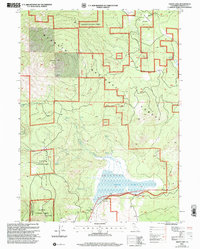
2001 Map of Grass Lake
USGS Topo · Published 2004About this map
Klamath National Forest dominates this high-altitude landscape of Siskiyou County, where the topography is defined by significant volcanic and mountain features. The eastern slope of Goosenest rises sharply in the northwest, while Miller Mountain and Herd Peak anchor the southwestern corner. Centrally, the seasonal waters of Grass Lake gather from drainages like Dairy Creek and Bear Wallow Creek, creating a critical wetland habitat amidst the timber.
Find a feature on this map
16 named features on this map. Tap any name to fly to it.
Don’t see what you’re looking for? This feature index may not catch every label — zoom into the map to look around manually.
Map Details
Editions of this 2001 Grass Lake Map
This is the sole edition of this map. No revisions or reprints were ever made.
Other maps of this area

1886 · Shasta
USGS Topo · 1:250,000

1894 · Shasta
USGS Topo · 1:250,000

1922 · Shasta Valley Sheet No 10 E
USGS Topo · 1:24,000

1934 · Macdoel
USGS Topo · 1:96,000

1941 · Macdoel
USGS Topo · 1:125,000

1948 · Weed
USGS Topo · 1:250,000

1950 · Weed
USGS Topo · 1:250,000

1954 · The Whaleback
USGS Topo · 1:62,500

1954 · Macdoel
USGS Topo · 1:62,500
1954 · Copco
USGS Topo · 1:62,500