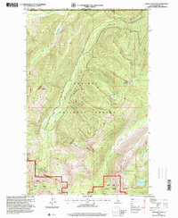
1996 Map of Grass Mountain
USGS Topo · Published 1999About this map
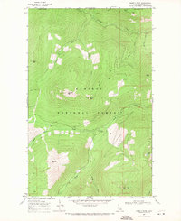
Kaniksu National Forest and Priest Lake State Forest dominate this high-altitude landscape along the international border between Canada and the United States. The terrain is defined by a series of prominent summits including Grass Mountain, Blue Joe Mountain, and Trapper Peak, which overlook a complex drainage system of named waters like Bog Creek and Blue Joe Creek. Evidence of local industry and resource extraction appears at the Parker Mine and a Gravel Pit near the southern edge of the forest boundaries. The map details a network of high-mountain lakes, such as Saddle Lake, Search Lake, and Joe Lake, which are connected by small streams like Saddle Creek and Silver Creek. This 1990s revision by the Forest Service provides a detailed view of the remote drainage patterns and crests at the northernmost reaches of Idaho.
Find a feature on this map
26 named features on this map. Tap any name to fly to it.
Don’t see what you’re looking for? This feature index may not catch every label — zoom into the map to look around manually.
Map Details
Editions of this 1996 Grass Mountain Map
This is the sole edition of this map. No revisions or reprints were ever made.
Other maps of this area

1911 · Priest Lake
USGS Topo · 1:250,000

1913 · Priest Lake
USGS Topo · 1:250,000

1958 · Sandpoint
USGS Topo · 1:250,000

1963 · Sandpoint
USGS Topo · 1:250,000
1968 · Continental Mtn
USGS Topo · 1:24,000

1969 · Grass Mountain
USGS Topo · 1:24,000
1969 · Caribou Creek
USGS Topo · 1:24,000
1969 · Upper Priest Lake
USGS Topo · 1:24,000
1969 · Shorty Peak
USGS Topo · 1:24,000
1969 · Smith Peak
USGS Topo · 1:24,000