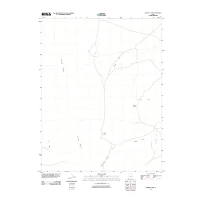
2010 Map of Grassy Cove
USGS Topo · Published 2010About this map
The Wah Wah Mountains dominate the western landscape of this Millard County quadrant, forming a high barrier that overlooks the arid expanses of the surrounding basins. This topographic study captures a complex system of drainage and passage through the range, defined by the winding course of Lawson Cove Canyon and the transition into the Wah Wah Valley to the east. The terrain is marked by strategic mountain crossings including Upper Pass and Middle Pass, which connect the remote Pine Valley with the eastern flats. Toward the northeast, the Gray Hills provide a distinct geological contrast to the primary mountain spine, while the namesake Grassy Cove marks a significant topographic depression. The map reflects a landscape defined by its isolation and the network of unpaved tracks that follow the natural contours of the coves and valleys.
Find a feature on this map
9 named features on this map. Tap any name to fly to it.
Don’t see what you’re looking for? This feature index may not catch every label — zoom into the map to look around manually.
Map Details
Editions of this 2010 Grassy Cove Map
This is the sole edition of this map. No revisions or reprints were ever made.
Other maps of this area

1953 · Richfield
USGS Topo · 1:250,000

1958 · Richfield
USGS Topo · 1:250,000

1960 · Frisco Peak
USGS Topo · 1:62,500

1960 · Wah Wah Summit
USGS Topo · 1:62,500

1960 · Crystal Peak
USGS Topo · 1:62,500

1960 · The Barn
USGS Topo · 1:62,500

1980 · Wah Wah Mts. North
USGS Topo · 1:100,000
1989 · Wah Wah Cove
USGS Topo · 1:24,000
1989 · Wah Wah Summit
USGS Topo · 1:24,000
1989 · Pine Valley Hardpan South
USGS Topo · 1:24,000