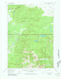
1956 Map of Grassy Lake Reservoir
USGS Topo · Published 1978About this map
The rugged intersection of three major protected wilderness areas—Yellowstone National Park, Targhee National Forest, and Grand Teton National Park—comes into focus in this mid-1950s survey. The landscape is defined by the complex water systems of the Falls River Basin, where the Bechler River drops through Bechler Canyon over notable heights such as Colonnade Falls and Iris Falls. Evidence of early land use and high-altitude activity appears at the Lucky Lady Mine near Grizzly Creek and the remote Patrol Cabin situated near the Teton Co boundary.
Find a feature on this map
74 named features on this map. Tap any name to fly to it.
Don’t see what you’re looking for? This feature index may not catch every label — zoom into the map to look around manually.
Map Details
Editions of this 1956 Grassy Lake Reservoir Map
4 editions found

Other maps of this area

1886 · Shoshone
USGS Topo · 1:125,000

1888 · Shoshone
USGS Topo · 1:125,000

1895 · Shoshone
USGS Topo · 1:125,000

1899 · Grand Teton
USGS Topo · 1:125,000

1901 · Shoshone
USGS Topo · 1:125,000

1901 · Grand Teton
USGS Topo · 1:125,000

1908 · Shoshone
USGS Topo · 1:125,000

1911 · Shoshone
USGS Topo · 1:125,000

1955 · Ashton
USGS Topo · 1:250,000

1955 · Driggs
USGS Topo · 1:250,000