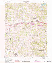
1962 Map of Gratiot
USGS Topo · Published 1990About this map
Flint Ridge dominates the northern topography of this region, where the boundaries of Licking and Muskingum counties meet. The landscape is defined by the east-west corridor of the highway through Gratiot and Mt Sterling, which also served as the local post office. While agricultural patterns are evident, the presence of several Strip Mines and a Drill Hole near Painter Run point to the area's extractive history during the early 1960s.
Find a feature on this map
34 named features on this map. Tap any name to fly to it.
Don’t see what you’re looking for? This feature index may not catch every label — zoom into the map to look around manually.
Map Details
Editions of this 1962 Gratiot Map
3 editions found
Other maps of this area

1909 · Newark
USGS Topo · 1:62,500

1909 · Thornville
USGS Topo · 1:62,500

1910 · Frazeysburg
USGS Topo · 1:62,500

1910 · Zanesville
USGS Topo · 1:62,500

1947 · Columbus
USGS Topo · 1:250,000

1950 · Marion
USGS Topo · 1:250,000

1961 · Columbus
USGS Topo · 1:250,000

1961 · Hanover
USGS Topo · 1:24,000

1961 · Zanesville West
USGS Topo · 1:24,000
1961 · Fultonham
USGS Topo · 1:24,000