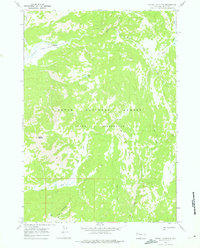
1965 Map of Gravel Mountain
USGS Topo · Published 1975About this map
Teton Wilderness and the surrounding Teton National Forest dominate this mid-century topographic survey, capturing a high-elevation landscape defined by the Continental Divide's hydrological headwaters. The map illustrates the convergence of Pacific Creek and Atlantic Creek, a geographically significant point where waters part toward opposite oceans. The terrain is marked by prominent elevations such as Gravel Mountain and Mount Randolph, while the interior remains accessible only by a network of established paths like the Divide Trail. Remote water bodies, including Enos Lake and Moss Lake, are mapped alongside the drainage systems of Lava Creek and Box Creek. This 1964 photogrammetric record preserves the primitive character of the region before modern wilderness management further restricted such surveying efforts.
Find a feature on this map
21 named features on this map. Tap any name to fly to it.
Don’t see what you’re looking for? This feature index may not catch every label — zoom into the map to look around manually.
Map Details
Editions of this 1965 Gravel Mountain Map
2 editions found
Other maps of this area

1885 · Lake
USGS Topo · 1:125,000

1895 · Lake
USGS Topo · 1:125,000

1896 · Lake
USGS Topo · 1:125,000

1901 · Lake
USGS Topo · 1:125,000

1902 · Mt Leidy
USGS Topo · 1:125,000

1906 · Lake
USGS Topo · 1:125,000

1911 · Lake
USGS Topo · 1:125,000

1955 · Ashton
USGS Topo · 1:250,000

1955 · Driggs
USGS Topo · 1:250,000

1958 · Driggs
USGS Topo · 1:250,000