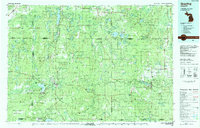
1983 Map of Grayling
USGS Topo · Published 1984About this map
Camp Grayling Military Reservation dominates the central landscape of this 1980s topographic study, surrounded by a complex network of public lands including the Au Sable State Forest, Mackinaw State Forest, and Huron National Forest. The map documents a region defined by its recreational and natural resources, featuring Hartwick Pines State Park and a dense constellation of glacial lakes like Otsego Lake and the Spectacle Lakes.
Find a feature on this map
112 named features on this map. Tap any name to fly to it.
Don’t see what you’re looking for? This feature index may not catch every label — zoom into the map to look around manually.
Map Details
Editions of this 1983 Grayling Map
2 editions found
Other maps of this area

1949 · Black Creek
USGS Topo · 1:24,000

1949 · Lewiston
USGS Topo · 1:62,500

1949 · Otsego Lake
USGS Topo · 1:62,500

1949 · Fletcher
USGS Topo · 1:62,500

1949 · Grayling
USGS Topo · 1:62,500

1950 · Cote Dame Marie
USGS Topo · 1:24,000

1950 · Fletcher
USGS Topo · 1:24,000

1950 · Lake Margrethe
USGS Topo · 1:24,000

1950 · Grayling
USGS Topo · 1:24,000

1950 · Lewiston
USGS Topo · 1:24,000