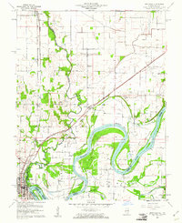
1959 Map of Grayville
USGS Topo · Published 1961About this map
The Wabash River carves a complex, meandering path across this 1959 survey, defining the border between Illinois and Indiana through a series of dramatic loops including Peankishaw Bend and Schuh Bend. The landscape is a mosaic of riparian bottomlands and upland agriculture, with Bonpas Creek flowing south to meet the river near the community of Grayville. This town serves as a local hub at the junction of the Illinois Central and New York Central railroads, reflecting a period when rail transport was central to the region's economy.
Find a feature on this map
31 named features on this map. Tap any name to fly to it.
Don’t see what you’re looking for? This feature index may not catch every label — zoom into the map to look around manually.
Map Details
Editions of this 1959 Grayville Map
3 editions found
Other maps of this area

1903 · New Harmony
USGS Topo · 1:62,500

1903 · Patoka
USGS Topo · 1:125,000

1904 · Mount Carmel
USGS Topo · 1:62,500

1938 · New Harmony
USGS Topo · 1:62,500

1940 · Carmi
USGS Topo · 1:62,500

1943 · Carmi
USGS Topo · 1:62,500

1943 · Albion
USGS Topo · 1:62,500

1946 · Albion
USGS Topo · 1:62,500

1956 · Vincennes
USGS Topo · 1:250,000

1957 · Vincennes
USGS Topo · 1:250,000