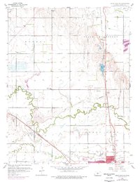
1959 Map of Great Bend NE
USGS Topo · Published 1977About this map
The meanders of Walnut Creek and Blood Creek define the prairie landscape of Barton County as it transitioned through the mid-20th century. Just north of Great Bend, the map reveals a meticulously organized countryside where school districts and rural life intersected with burgeoning industry. Local education was rooted in facilities like School No 45 and Countryside Sch, while the regional economy leveraged the Atchison Topeka and Santa Fe and Missouri Pacific railroads to move resources from numerous Oil Wells and a local Claypit.
Find a feature on this map
35 named features on this map. Tap any name to fly to it.
Don’t see what you’re looking for? This feature index may not catch every label — zoom into the map to look around manually.
Map Details
Editions of this 1959 Great Bend NE Map
3 editions found
Other maps of this area

1891 · Great Bend
USGS Topo · 1:125,000

1893 · Great Bend
USGS Topo · 1:125,000

1896 · Russell
USGS Topo · 1:125,000

1955 · Great Bend
USGS Topo · 1:250,000

1956 · Ellinwood NW
USGS Topo · 1:24,000

1957 · Great Bend
USGS Topo · 1:250,000

1957 · Ellinwood SW
USGS Topo · 1:24,000

1958 · Great Bend
USGS Topo · 1:250,000

1958 · Great Bend
USGS Topo · 1:24,000

1959 · Great Bend NE
USGS Topo · 1:24,000