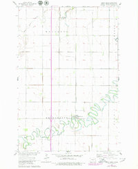
1964 Map of Great Bend
USGS Topo · Published 1979About this map
Wild Rice River meanders dramatically across the landscape of southern Richland County, its tight oxbows defining the geography of the Brandenburg and Summit townships. This 1964 survey, with revisions added in 1979, documents the village of Great Bend as a vital rail point along the Northern Pacific railroad line. The map highlights the intersection of transportation and settlement in the Red River Valley, where the rail corridor parallels the north-south section lines through Mooreton and Center.
Find a feature on this map
10 named features on this map. Tap any name to fly to it.
Don’t see what you’re looking for? This feature index may not catch every label — zoom into the map to look around manually.
Map Details
Editions of this 1964 Great Bend Map
2 editions found
Other maps of this area

1904 · Wahpeton
USGS Topo · 1:125,000

1953 · Fargo
USGS Topo · 1:250,000

1956 · Fargo
USGS Topo · 1:250,000

1960 · Mooreton West
USGS Topo · 1:24,000

1960 · Mooreton East
USGS Topo · 1:24,000

1964 · Hankinson
USGS Topo · 1:24,000

1964 · Fairmount NW
USGS Topo · 1:24,000

1964 · Mantador
USGS Topo · 1:24,000

1964 · Hankinson SE
USGS Topo · 1:24,000

1964 · Great Bend
USGS Topo · 1:24,000