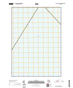
2018 Map of Green Bay (All Water)
USGS Topo · Published 2018About this map
Lake Michigan and the expanse of Green Bay dominate this specialized nautical survey, where the terrestrial world is reduced to a single diagonal boundary line. This 2018 chart represents a distinct portion of the Wisconsin maritime landscape where no landmasses are present, focusing instead on the aquatic intersection of two prominent counties. The Marinette Co and Door Co administrative line cuts across the water, providing a rare perspective on how legal and regional boundaries are maintained even miles from the shoreline. Researchers of maritime history or administrative cartography will find interest in the precise placement of this county divider through the open waters of the bay.
Find a feature on this map
3 named features on this map. Tap any name to fly to it.
Don’t see what you’re looking for? This feature index may not catch every label — zoom into the map to look around manually.
Map Details
Editions of this 2018 Green Bay (All Water) Map
This is the sole edition of this map. No revisions or reprints were ever made.
Other maps of this area

1939 · Marinette
USGS Topo · 1:48,000

1954 · Escanaba
USGS Topo · 1:250,000

1954 · Manitowoc
USGS Topo · 1:250,000

1957 · Escanaba
USGS Topo · 1:250,000

1958 · Escanaba
USGS Topo · 1:250,000

1958 · Manitowoc
USGS Topo · 1:250,000

1960 · Sturgeon Bay
USGS Topo · 1:62,500

1961 · Little Sturgeon
USGS Topo · 1:62,500

1961 · Chambers Island
USGS Topo · 1:62,500
1963 · Marinette West
USGS Topo · 1:24,000