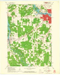
1963 Map of Marinette West
USGS Topo · Published 1964About this map
The Menominee River serves as the state boundary between Marinette, Wisconsin, and Menominee, Michigan, in this early 1960s study. The industrial and educational character of the Twin Cities is evident through the presence of the County Teachers College, Jordan Seminary, and the Armory. To the southwest, the city of Peshtigo is situated along the bends of the Peshtigo River, surrounded by several educational and civic landmarks such as the Garfield Sch and County Hospital. The landscape is dominated by the complex rail infrastructure of the Chicago and North Western and the Chicago Milwaukee St Paul and Pacific railroads, which facilitated the region's timber and manufacturing economies. Extensive cemetery grounds, including Forest Home Cemetery and Calvary Cem, provide significant genealogical reference points, while the Peshtigo Harbor Wildlife Area marks the transition toward the Green Bay shoreline.
Find a feature on this map
44 named features on this map. Tap any name to fly to it.
Don’t see what you’re looking for? This feature index may not catch every label — zoom into the map to look around manually.
Map Details
Editions of this 1963 Marinette West Map
2 editions found
Other maps of this area

1939 · Marinette
USGS Topo · 1:48,000

1939 · Porterfield
USGS Topo · 1:48,000

1942 · Porterfield
USGS Topo · 1:48,000

1954 · Escanaba
USGS Topo · 1:250,000

1954 · Manitowoc
USGS Topo · 1:250,000

1956 · Oconto
USGS Topo · 1:62,500

1957 · Escanaba
USGS Topo · 1:250,000

1958 · Escanaba
USGS Topo · 1:250,000

1958 · Manitowoc
USGS Topo · 1:250,000

1961 · Little Sturgeon
USGS Topo · 1:62,500