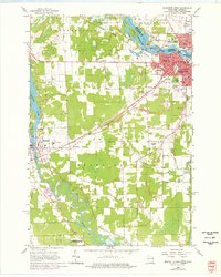
1963 Map of Marinette West
USGS Topo · Published 1977About this map
The industrial and civic centers of Marinette, Wisconsin, and Menominee, Michigan, converge at the mouth of the Menominee River during this mid-century period. The map highlights a landscape defined by significant paper and timber heritage, with several river features like Boom Island and Blueberry I indicating the waterway's working history. Institutional landmarks such as Jordan Seminary, County Teachers College, and the Armory reflect the regional importance of the area. To the southwest, the Peshtigo River winds through the landscape toward the Peshtigo Harbor State Wildlife Area, passing the city of Peshtigo. Transport corridors of the Chicago and North Western and the Chicago Milwaukee St Paul and Pacific railroads cut across the terrain, linking the industrial riverfronts to the interior farmlands and local schools like Stewart Sch and Garfield Sch.
Find a feature on this map
56 named features on this map. Tap any name to fly to it.
Don’t see what you’re looking for? This feature index may not catch every label — zoom into the map to look around manually.
Map Details
Editions of this 1963 Marinette West Map
2 editions found
Other maps of this area

1939 · Marinette
USGS Topo · 1:48,000

1939 · Porterfield
USGS Topo · 1:48,000

1942 · Porterfield
USGS Topo · 1:48,000

1954 · Escanaba
USGS Topo · 1:250,000

1954 · Manitowoc
USGS Topo · 1:250,000

1956 · Oconto
USGS Topo · 1:62,500

1957 · Escanaba
USGS Topo · 1:250,000

1958 · Escanaba
USGS Topo · 1:250,000

1958 · Manitowoc
USGS Topo · 1:250,000

1961 · Little Sturgeon
USGS Topo · 1:62,500