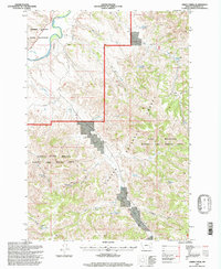
1995 Map of Green Creek
USGS Topo · Published 1998About this map
The Northern Cheyenne Indian Reservation and the Custer National Forest converge in this high-plains landscape, where the Tongue River carves through the distinct Tongue River Breaks. This mid-1990s survey illustrates a specialized land-use pattern, highlighting designated recreational zones like the Tongue River Breaks Hiking and Riding Area and the King Mountain Hiking and Riding Area. The topography is defined by its water management systems, crucial for ranching in this arid environment. A network of small-scale reservoirs and wells, such as the East Fork Reservoir, Schaudel Reservoir, and the O'Dell Windmill, are scattered across the draws and creeks. The presence of the Bull Ranch underscores the area's agricultural identity, while labels for King Creek Well No 1 and others point to localized resource development within the forest boundaries.
Find a feature on this map
37 named features on this map. Tap any name to fly to it.
Don’t see what you’re looking for? This feature index may not catch every label — zoom into the map to look around manually.
Map Details
Editions of this 1995 Green Creek Map
This is the sole edition of this map. No revisions or reprints were ever made.
Other maps of this area

1954 · Hardin
USGS Topo · 1:250,000

1957 · Hardin
USGS Topo · 1:250,000

1958 · Hardin
USGS Topo · 1:250,000

1958 · Hollowwood Creek
USGS Topo · 1:24,000

1966 · Browns Mountain
USGS Topo · 1:24,000

1966 · Ashland
USGS Topo · 1:24,000

1966 · Birney Day School
USGS Topo · 1:24,000

1966 · Poker Jim Butte
USGS Topo · 1:24,000

1966 · Fort Howes
USGS Topo · 1:24,000

1966 · King Mountain
USGS Topo · 1:24,000