
1952 Map of Green Island
USGS Topo · Published 1953About this map
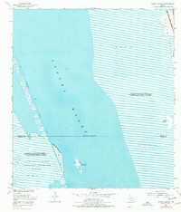
Green Island (Bird Sanctuary) sits as a focal point within the coastal waters of Laguna Madre, where the boundaries of Willacy and Cameron counties meet. This 1952 topographic survey illustrates a transition in the South Texas landscape, documenting the established Laguna Atascosa National Wildlife Refuge and the engineering of the Intracoastal Waterway. The map details the artificial topography created by the dredging of the shipping channel, specifically the chain of Spoil Banks that parallel the deep-water passage. To the east, the barrier of Padre Island is depicted with its Shifting Sand Dunes, protecting the shallow Sand and Mud Flats that characterize this tidal environment. The presence of a Tower and multiple lights along the waterway highlights the area's importance for coastal navigation during the early 1950s.
Find a feature on this map
15 named features on this map. Tap any name to fly to it.
Don’t see what you’re looking for? This feature index may not catch every label — zoom into the map to look around manually.
Map Details
Editions of this 1952 Green Island Map
2 editions found
Other maps of this area

1929 · Buena Vista
USGS Topo · 1:24,000

1930 · La Leona
USGS Topo · 1:24,000

1930 · Padre Island No. 2
USGS Topo · 1:24,000

1935 · Padre Island NO. 2
USGS Topo · 1:31,680

1935 · Buena Vista
USGS Topo · 1:31,680

1936 · La Leona
USGS Topo · 1:31,680
1952 · North Of Port Isabel NW
USGS Topo · 1:24,000

1952 · South of Potrero Lopeno SE
USGS Topo · 1:24,000

1952 · Hawk Island
USGS Topo · 1:24,000

1952 · Port Mansfield
USGS Topo · 1:24,000