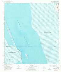
1952 Map of Green Island
USGS Topo · Published 1977About this map
Green Island (Bird Sanctuary) serves as a focal point within the expansive Laguna Madre, where the coastal environment remains largely defined by natural boundaries and maritime navigation. Surveyed in the early 1950s, this area captures a landscape of transition between the mainland and the barrier islands. The Intracoastal Waterway cuts a precise path through the western reaches, flanked by numerous Spoil Banks and navigational lights. To the east, the Padre Island National Seashore is marked by Shifting Sand Dunes, while the southwest corner includes a portion of the Laguna Atascosa National Wildlife Refuge. The map illustrates a complex system of Sand and Mud Flats and tide-dependent shorelines, revealing the raw coastal geography of Willacy and Cameron counties before significant modern development altered these shores.
Find a feature on this map
16 named features on this map. Tap any name to fly to it.
Don’t see what you’re looking for? This feature index may not catch every label — zoom into the map to look around manually.
Map Details
Editions of this 1952 Green Island Map
2 editions found
Other maps of this area

1929 · Buena Vista
USGS Topo · 1:24,000

1930 · La Leona
USGS Topo · 1:24,000

1930 · Padre Island No. 2
USGS Topo · 1:24,000

1935 · Padre Island NO. 2
USGS Topo · 1:31,680

1935 · Buena Vista
USGS Topo · 1:31,680

1936 · La Leona
USGS Topo · 1:31,680

1952 · Green Island
USGS Topo · 1:24,000
1952 · North Of Port Isabel NW
USGS Topo · 1:24,000

1952 · South of Potrero Lopeno SE
USGS Topo · 1:24,000

1952 · Hawk Island
USGS Topo · 1:24,000