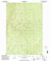
1995 Map of Green Mountain
USGS Topo · Published 1999About this map
Green Mountain and its high-elevation Lookout tower over the drainage basins of the Nez Perce National Forest in this mid-1990s update of 1960s topography. The landscape is defined by its complex hydrology, where Running Creek and its many tributaries, including South Fork Running Creek, flow through deeply incised valleys. Notable landmarks include the high-altitude Elk Lake and prominent summits such as Granite Peak and Little Green Mountain.
Find a feature on this map
19 named features on this map. Tap any name to fly to it.
Don’t see what you’re looking for? This feature index may not catch every label — zoom into the map to look around manually.
Map Details
Editions of this 1995 Green Mountain Map
This is the sole edition of this map. No revisions or reprints were ever made.
Other maps of this area

1956 · Elk City
USGS Topo · 1:250,000

1960 · Elk City
USGS Topo · 1:250,000

1966 · Green Mtn.
USGS Topo · 1:24,000

1966 · Three Prong Mountain
USGS Topo · 1:24,000
1966 · Wylies Peak
USGS Topo · 1:24,000

1966 · Sable Hill
USGS Topo · 1:24,000
1966 · Running Lake
USGS Topo · 1:24,000
1966 · Vermilion Peak
USGS Topo · 1:24,000

1977 · Boston Mtn
USGS Topo · 1:24,000

1978 · Spread Creek Point
USGS Topo · 1:24,000