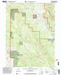
2000 Map of Green Ridge
USGS Topo · Published 2004About this map
Routt National Forest defines this high-elevation landscape in the year 2000, where the drainage networks of Morrison Creek and Muddy Creek carve through the Green Ridge terrain. The map captures a moment of modern land management, showing the protected Sarvis Creek Wilderness in the northeast and the infrastructure of the Stagecoach Ski Area and its Ski Lift system in the northwest. Local topography is marked by significant landmarks like Simpson Mountain and Eagle Rock, while the presence of Lower Silver Creek Springs indicates the essential water sources in this backcountry area. High-altitude recreation and resource monitoring are evident through the network of routes such as the Silver Creek Trail and Muddy Creek Trail, which navigate around the massive geological features of Wheeler Basin and the area simply labeled Slide.
Find a feature on this map
26 named features on this map. Tap any name to fly to it.
Don’t see what you’re looking for? This feature index may not catch every label — zoom into the map to look around manually.
Map Details
Editions of this 2000 Green Ridge Map
This is the sole edition of this map. No revisions or reprints were ever made.
Other maps of this area

1954 · Craig
USGS Topo · 1:250,000

1956 · Walton Peak
USGS Topo · 1:24,000

1956 · Gore Pass
USGS Topo · 1:62,500

1956 · Rabbit Ears Peak
USGS Topo · 1:62,500

1957 · Craig
USGS Topo · 1:250,000

1958 · Craig
USGS Topo · 1:250,000

1960 · Craig
USGS Topo · 1:250,000

1962 · Craig
USGS Topo · 1:250,000

1964 · Craig
USGS Topo · 1:250,000

1965 · Craig
USGS Topo · 1:250,000