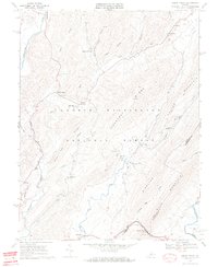
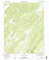
1969 Map of Green Valley
USGS Topo · Published 1970About this map
The Cowpasture River and Calfpasture River define the western and southeastern reaches of this topography, situated within the expansive George Washington National Forest. Settlement patterns follow the narrow valleys and gaps between the high ridges of Chestnut Ridge and Walker Mountain, where small communities like Armstrong and Hotchkiss are anchored by local landmarks. The presence of multiple country churches, such as Cloverdale Ch and Rehobeth Ch, suggests established rural congregations serving the families along Mill Creek and Stuart Run. A single line of the Chesapeake and Ohio railroad threads through Panther Gap Creek in the south, providing a critical transport link through the mountains. Natural springs like White Sulphur Spring and McCowan Spring dot the landscape, indicating the importance of reliable water sources in this complex terrain of drafts and hollows.
Find a feature on this map
39 named features on this map. Tap any name to fly to it.
Don’t see what you’re looking for? This feature index may not catch every label — zoom into the map to look around manually.
Map Details
Editions of this 1969 Green Valley Map
5 editions found
Other maps of this area

1894 · Staunton
USGS Topo · 1:125,000

1894 · Natural Bridge
USGS Topo · 1:125,000

1894 · Lexington
USGS Topo · 1:125,000

1901 · Monterey
USGS Topo · 1:125,000

1932 · Lexington
USGS Topo · 1:48,000

1937 · Lexington
USGS Topo · 1:62,500

1943 · Craigsville
USGS Topo · 1:62,500

1945 · Craigsville
USGS Topo · 1:62,500

1946 · Millboro
USGS Topo · 1:62,500

1946 · Williamsville
USGS Topo · 1:62,500