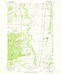
1969 Map of Greenberry
USGS Topo · Published 1973About this map
The William L Finley National Wildlife Refuge anchors the southern half of this Benton County landscape, preserving the marshy bottomlands of Muddy Creek and McFadden Creek. This 1969 field-checked survey reveals a rural economy organized around the Southern Pacific railroad line, which passes through the small shipping points of Shrock and Greenberry. To the west, the foothills of the Coast Range begin to rise, marked by local landmarks like Mill Hill, Pigeon Butte, and Winkle Butte.
Find a feature on this map
41 named features on this map. Tap any name to fly to it.
Don’t see what you’re looking for? This feature index may not catch every label — zoom into the map to look around manually.
Map Details
Editions of this 1969 Greenberry Map
3 editions found
Other maps of this area

1909 · Harrisburg
USGS Topo · 1:31,680

1911 · Monroe
USGS Topo · 1:31,680

1911 · Inavale
USGS Topo · 1:31,680

1912 · Halsey
USGS Topo · 1:62,500

1913 · Philomath
USGS Topo · 1:31,680

1913 · Oakville
USGS Topo · 1:31,680

1916 · Albany
USGS Topo · 1:62,500

1921 · Corvallis
USGS Topo · 1:62,500

1922 · Monroe
USGS Topo · 1:62,500

1939 · Monroe
USGS Topo · 1:62,500