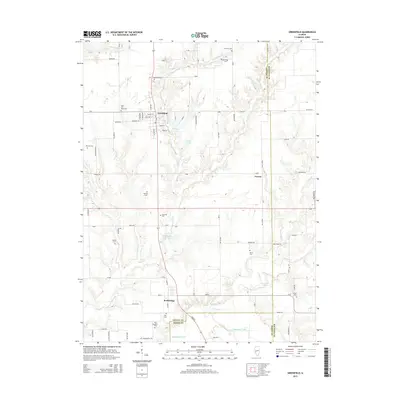
2015 Map of Greenfield
USGS Topo · Published 2015About this map
Greenfield serves as the primary hub of this Greene County landscape, where the street grid is clearly defined by thoroughfares like Prairie St and College St. The surrounding countryside is defined by an unusually high density of family and community burial grounds, providing a significant resource for genealogical research. These sites, including Oakwood Cem, Rose Hill West Cem, and Mitchell Cem, are scattered across the terrain between the winding courses of Taylor Cr and Rubicon Cr. To the south, the settlement of Rockbridge sits near the confluence of local streams and Macoupin Creek, while the small community of Fayette occupies the eastern portion of the map. Water features like Coles Lake and the interestingly named Shady Eighty Acres Lake punctuate the agricultural lands, reflecting the area's rural character and its reliance on the local creek systems for drainage and geography.
Find a feature on this map
88 named features on this map. Tap any name to fly to it.
Don’t see what you’re looking for? This feature index may not catch every label — zoom into the map to look around manually.
Map Details
Editions of this 2015 Greenfield Map
This is the sole edition of this map. No revisions or reprints were ever made.
Other maps of this area

1924 · Roodhouse
USGS Topo · 1:62,500

1925 · Brighton
USGS Topo · 1:62,500

1926 · Roodhouse
USGS Topo · 1:62,500

1928 · Brighton
USGS Topo · 1:62,500

1930 · Jerseyville
USGS Topo · 1:62,500

1932 · Greenfield
USGS Topo · 1:62,500

1933 · Jerseyville
USGS Topo · 1:62,500

1948 · Quincy
USGS Topo · 1:250,000

1956 · Quincy
USGS Topo · 1:250,000
1982 · Summerville
USGS Topo · 1:24,000