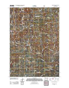
2011 Map of Greenhorn
USGS Topo · Published 2011About this map
Greenhorn and the nearby site of Robinsonville anchor this 2011 survey of the high-country landscape where Baker and Grant counties meet. The area is defined by a dense network of watercourses and meadows, including the North Fork Burnt River, Beaver Creek, and Geiser Creek. High-altitude clearings like Beaver Meadows, Howard Meadow, and Lobelia Meadow dot the terrain, while landmarks such as Olive Butte and San Lou Flat provide distinct geographic markers.
Find a feature on this map
56 named features on this map. Tap any name to fly to it.
Don’t see what you’re looking for? This feature index may not catch every label — zoom into the map to look around manually.
Map Details
Editions of this 2011 Greenhorn Map
This is the sole edition of this map. No revisions or reprints were ever made.
Other maps of this area

1901 · Sumpter
USGS Topo · 1:125,000

1951 · Bates
USGS Topo · 1:62,500

1951 · Desolation Butte
USGS Topo · 1:62,500

1955 · Canyon City
USGS Topo · 1:250,000

1959 · Canyon City
USGS Topo · 1:250,000

1961 · Whitney
USGS Topo · 1:24,000

1972 · Austin
USGS Topo · 1:24,000

1972 · Mt. Ireland
USGS Topo · 1:24,000
1972 · Granite
USGS Topo · 1:24,000

1972 · Greenhorn
USGS Topo · 1:24,000