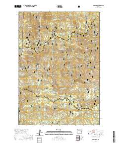
2020 Map of Greenhorn
USGS Topo · Published 2020About this map
Greenhorn and the nearby site of Robinsonville sit high in the Blue Mountains at the crossing of the Grant and Baker County lines. This 2020 map documents the complex terrain of the Elkhorn Range, where high-altitude water management is evident in features like the Placer Ditch and numerous gulches such as California Gulch and McWillis Gulch. The landscape is dominated by the intersection of three major forest boundaries: the Umatilla National Forest, Whitman National Forest, and Malheur National Forest. In the southern reaches, the geography softens into Whitney Valley and Taylor Flat, drained by the N Fork Burnt River. The presence of the Greenhorn Cem and the Austin Spur road provides tangible evidence of the area's gold-mining heritage and early transportation networks that once connected these remote mountain outposts.
Find a feature on this map
65 named features on this map. Tap any name to fly to it.
Don’t see what you’re looking for? This feature index may not catch every label — zoom into the map to look around manually.
Map Details
Editions of this 2020 Greenhorn Map
This is the sole edition of this map. No revisions or reprints were ever made.
Other maps of this area

1901 · Sumpter
USGS Topo · 1:125,000

1951 · Bates
USGS Topo · 1:62,500

1951 · Desolation Butte
USGS Topo · 1:62,500

1955 · Canyon City
USGS Topo · 1:250,000

1959 · Canyon City
USGS Topo · 1:250,000

1961 · Whitney
USGS Topo · 1:24,000

1972 · Austin
USGS Topo · 1:24,000

1972 · Mt. Ireland
USGS Topo · 1:24,000
1972 · Granite
USGS Topo · 1:24,000

1972 · Greenhorn
USGS Topo · 1:24,000