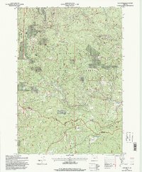
1995 Map of Greenhorn
USGS Topo · Published 1998About this map
Greenhorn stands as a focal point in this high-elevation landscape of the Blue Mountains, straddling the line between Baker and Grant Counties. This mid-1990s survey preserves the footprint of a region defined by its gold mining heritage, marking numerous historical operations such as the Golden Gate Mine, Bonanza Mine, and Humbolt Mine. Evidence of industrial-scale extraction is visible along the watercourses, particularly the extensive Dredge Tailings near Parkerville. The map documents the sites of former settlements like Robinsonville and Tipton, which were once integral to the area's timber and mining economies. Natural features like San Lou Flat and the headwaters of the Burnt River are surrounded by the designated Vinegar Hill-Indian Rock Scenic Area, illustrating the intersection of resource extraction and modern wilderness conservation.
Find a feature on this map
61 named features on this map. Tap any name to fly to it.
Don’t see what you’re looking for? This feature index may not catch every label — zoom into the map to look around manually.
Map Details
Editions of this 1995 Greenhorn Map
This is the sole edition of this map. No revisions or reprints were ever made.
Other maps of this area

1901 · Sumpter
USGS Topo · 1:125,000

1951 · Bates
USGS Topo · 1:62,500

1951 · Desolation Butte
USGS Topo · 1:62,500

1955 · Canyon City
USGS Topo · 1:250,000

1959 · Canyon City
USGS Topo · 1:250,000

1961 · Whitney
USGS Topo · 1:24,000

1972 · Austin
USGS Topo · 1:24,000

1972 · Mt. Ireland
USGS Topo · 1:24,000
1972 · Granite
USGS Topo · 1:24,000

1972 · Greenhorn
USGS Topo · 1:24,000