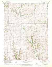
1968 Map of Greenleaf SE
USGS Topo · Published 1970About this map
Sulphur Creek and Swede Creek carve through the agricultural uplands of northern Riley County, where the landscape is defined by its rural community markers and the southern influence of the Tuttle Creek Reservoir. The late 1960s terrain shows a pattern of established farmsteads and civic foundations, including the local Townhall and the Peach Grove Ch. These social centers are supported by a network of family and community burial grounds such as Spring Valley Cem and the Fancy Creek-Randolph Cem. Private aviation is represented by the Potts Landing Strip, while the hydrological transition of the area is further documented by North Otter Creek and School Branch. This survey illustrates the steady rural character of the region just as major reservoir projects began to alter the local drainage and topography.
Find a feature on this map
22 named features on this map. Tap any name to fly to it.
Don’t see what you’re looking for? This feature index may not catch every label — zoom into the map to look around manually.
Map Details
Editions of this 1968 Greenleaf SE Map
2 editions found
Other maps of this area

1886 · Junction City
USGS Topo · 1:125,000

1889 · Marysville
USGS Topo · 1:125,000

1889 · Junction City
USGS Topo · 1:125,000

1894 · Junction City
USGS Topo · 1:125,000

1894 · Marysville
USGS Topo · 1:125,000

1955 · Manhattan
USGS Topo · 1:250,000

1956 · Manhattan
USGS Topo · 1:250,000

1957 · Manhattan
USGS Topo · 1:250,000
1963 · Lasita
USGS Topo · 1:24,000
1964 · Randolph
USGS Topo · 1:24,000