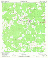
1981 Map of Greensburg
USGS Topo · Published 1981About this map
Greensburg serves as the focal point of this St. Helena Parish landscape, where the confluence of several vital watercourses, including the Tickfaw River and Twelvemile Creek, has shaped the settlement patterns of the region. The map reveals a high density of small family and community burial grounds, such as Foster Cem, Brumfield Cem, and Womack-Muse Cem, reflecting generations of local lineage and the rural distribution of the parish. Educational and medical infrastructure is anchored by the St Helena Sch and the Parish Hosp, while spiritual life is documented through landmarks like St Mary Ch and Womack Chapel. Beyond the town center, the terrain is defined by a dense network of timbered branches like Joseph Branch and Beaver Branch, interspersed with small-scale industrial activity such as Gravel Pit and scattered Drill Holes. This survey provides a clear look at the parish seat just as the surrounding landscape maintained its traditional rural character in the early 1980s.
Find a feature on this map
54 named features on this map. Tap any name to fly to it.
Don’t see what you’re looking for? This feature index may not catch every label — zoom into the map to look around manually.
Map Details
Editions of this 1981 Greensburg Map
This is the sole edition of this map. No revisions or reprints were ever made.
Other maps of this area

1940 · Roseland
USGS Topo · 1:31,680

1941 · Gilead
USGS Topo · 1:31,680

1941 · Chipola
USGS Topo · 1:31,680

1942 · Roseland
USGS Topo · 1:31,680

1942 · Montpelier
USGS Topo · 1:31,680

1942 · Liverpool
USGS Topo · 1:31,680

1942 · Pine Grove
USGS Topo · 1:31,680

1942 · Gilead
USGS Topo · 1:31,680

1945 · Chipola
USGS Topo · 1:31,680

1949 · Amite
USGS Topo · 1:31,680