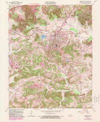
1963 Map of Greenville
USGS Topo · Published 1989About this map
Greenville serves as the hub of Muhlenberg County during this mid-century period, anchored by the Illinois Central railroad lines and the nearby Muhlenberg County Airport. The landscape is a complex mix of civic infrastructure and industrial activity, characterized by extensive strip mines that reveal the importance of the regional coal economy. Away from the larger settlements of Powderly and Luzerne, the countryside is dotted with local landmarks of genealogical significance, including the Williams Cem, Oak Grove Ch, and Roland Memorial Ch.
Find a feature on this map
40 named features on this map. Tap any name to fly to it.
Don’t see what you’re looking for? This feature index may not catch every label — zoom into the map to look around manually.
Map Details
Editions of this 1963 Greenville Map
4 editions found
Other maps of this area

1909 · Madisonville
USGS Topo · 1:62,500

1909 · Central City
USGS Topo · 1:62,500

1911 · Drakesboro
USGS Topo · 1:48,000

1912 · Nortonville
USGS Topo · 1:62,500

1913 · Drakesboro
USGS Topo · 1:62,500

1952 · Greenville
USGS Topo · 1:24,000

1953 · Drakesboro
USGS Topo · 1:24,000

1953 · Haleys Mill
USGS Topo · 1:24,000

1953 · Rosewood
USGS Topo · 1:24,000

1953 · Central City West
USGS Topo · 1:24,000