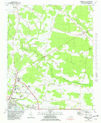
1981 Map of Greenville NE
USGS Topo · Published 1982About this map
Stokes and Whichard anchor the northeastern landscape of Pitt County in this early 1980s portrait of rural North Carolina. The area is defined by a dense network of country churches, including Post Oak Grove Ch, St Johns Ch, and Sweet Gum Grove Ch, which serve as long-standing community centers amid the agricultural fields. The Seaboard Coast Line railroad cuts diagonally across the terrain, passing through Staton and connecting the rural northern tracts to the northern outskirts of Greenville.
Find a feature on this map
37 named features on this map. Tap any name to fly to it.
Don’t see what you’re looking for? This feature index may not catch every label — zoom into the map to look around manually.
Map Details
Editions of this 1981 Greenville NE Map
This is the sole edition of this map. No revisions or reprints were ever made.
Other maps of this area

1901 · Parmele
USGS Topo · 1:62,500

1901 · Williamston
USGS Topo · 1:62,500

1902 · Williamston
USGS Topo · 1:62,500

1902 · Parmele
USGS Topo · 1:62,500

1903 · Winterville
USGS Topo · 1:62,500

1903 · Chocowinity
USGS Topo · 1:62,500

1905 · Chocowinity
USGS Topo · 1:62,500

1905 · Winterville
USGS Topo · 1:62,500

1953 · Rocky Mount
USGS Topo · 1:250,000

1954 · Rocky Mount
USGS Topo · 1:250,000
Featured Places
- Greenville, NC
- United Industrial Park, NC
- Buck Mobil Home Park, NC
- Shady Knoll Mobile Estates, NC
- Greenfield Terrace, NC