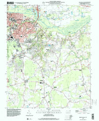
1998 Map of Greenville SE
USGS Topo · Published 2001About this map
East Carolina University and the expansion of southeast Greenville dominate the northwestern portion of this late 1990s survey, illustrating the institutional and residential growth of this regional hub. The university campus is shown in detail, including landmarks like Minges Coliseum and Ficklen Stadium. Outside the city limits, the landscape transitions into a network of crossroads communities and swampy lowlands. The intricate drainage patterns of Baldwin Swamp, Fork Swamp, and Indian Well Swamp are clearly visible, punctuated by traditional rural landmarks such as Hopewell Ch and Coteys Chapel.
Find a feature on this map
68 named features on this map. Tap any name to fly to it.
Don’t see what you’re looking for? This feature index may not catch every label — zoom into the map to look around manually.
Map Details
Editions of this 1998 Greenville SE Map
This is the sole edition of this map. No revisions or reprints were ever made.
Other maps of this area

1902 · Ayden
USGS Topo · 1:62,500

1902 · Vanceboro
USGS Topo · 1:62,500

1903 · Winterville
USGS Topo · 1:62,500

1903 · Chocowinity
USGS Topo · 1:62,500

1904 · Ayden
USGS Topo · 1:62,500

1904 · Vanceboro
USGS Topo · 1:62,500

1905 · Chocowinity
USGS Topo · 1:62,500

1905 · Winterville
USGS Topo · 1:62,500

1905 · Vanceboro
USGS Topo · 1:62,500

1953 · Rocky Mount
USGS Topo · 1:250,000