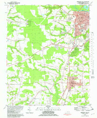
1981 Map of Greenville SW
USGS Topo · Published 1982About this map
Greenville and its southern suburbs expanded through the early 1980s, anchored by the Tar River and a network of small watercourses like Greens Mill Run and Gums Swamp. The landscape reveals a transition from the urban density of the city center—home to Jarvis Memorial Ch and the University—to the agricultural and residential fringes of Winterville and Renston. Industrial and communication infrastructure is prominent, marked by the extensive Voice of America facility in the northwest and multiple Radio Towers scattered near the Norfolk Southern and Seaboard Coast Line tracks.
Find a feature on this map
66 named features on this map. Tap any name to fly to it.
Don’t see what you’re looking for? This feature index may not catch every label — zoom into the map to look around manually.
Map Details
Editions of this 1981 Greenville SW Map
2 editions found
Other maps of this area

1902 · Ayden
USGS Topo · 1:62,500

1903 · Winterville
USGS Topo · 1:62,500

1904 · Ayden
USGS Topo · 1:62,500

1904 · Falkland
USGS Topo · 1:62,500

1905 · Winterville
USGS Topo · 1:62,500

1914 · Kinston
USGS Topo · 1:48,000

1916 · Kinston
USGS Topo · 1:62,500

1953 · Rocky Mount
USGS Topo · 1:250,000

1954 · Rocky Mount
USGS Topo · 1:250,000

1980 · Falkland
USGS Topo · 1:24,000