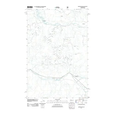
2011 Map of Greenwater
USGS Topo · Published 2011About this map
Greenwater sits at the confluence of the White River and the Greenwater River, serving as a focal point for this mountain landscape in the early twenty-first century. The map reveals a complex network of forest development roads, such as Nat For Dev Rd 54 and Nat For Dev Rd 7120, which thread through the drainage basins of Slippery Creek and Sylvester Creek. To the north, the small settlements of Humphrey and Maywood are situated along the upper reaches of the Green River, illustrating the historically sparse and resource-oriented residential patterns of this part of King County. Significant elevation markers like Humphrey Lookout and the aptly named Deadman Flat provide topographic context, while numerous smaller tributaries including West Twin Creek, East Twin Creek, and Rocky Run define the intricate watershed systems that feed into the region's major river arteries.
Find a feature on this map
29 named features on this map. Tap any name to fly to it.
Don’t see what you’re looking for? This feature index may not catch every label — zoom into the map to look around manually.
Map Details
Editions of this 2011 Greenwater Map
This is the sole edition of this map. No revisions or reprints were ever made.
Other maps of this area

1913 · Cedar Lake
USGS Topo · 1:125,000

1953 · Eagle Gorge
USGS Topo · 1:24,000

1956 · Greenwater
USGS Topo · 1:62,500

1956 · Enumclaw
USGS Topo · 1:62,500

1957 · Wenatchee
USGS Topo · 1:250,000

1960 · Bandera
USGS Topo · 1:62,500

1975 · Snoqualmie Pass
USGS Topo · 1:100,000
1986 · Bearhead Mtn
USGS Topo · 1:24,000
1986 · Nagrom
USGS Topo · 1:24,000
1986 · Clear West Peak
USGS Topo · 1:24,000