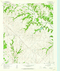
1961 Map of Greenwood
USGS Topo · Published 1964About this map
Clear Creek dominates the northeastern landscape of this Wise County region, serving as the primary drainage for a network of winding tributaries including Coon Creek and Fannin Creek. During the early 1960s, this area remained largely rural, defined by small crossroads settlements and family farmsteads scattered across the undulating terrain. The northern boundary with Cooke County is clearly marked, anchoring the community of Rosston near the upper reaches of the creek system.
Find a feature on this map
24 named features on this map. Tap any name to fly to it.
Don’t see what you’re looking for? This feature index may not catch every label — zoom into the map to look around manually.
Map Details
Editions of this 1961 Greenwood Map
2 editions found
Other maps of this area

1902 · Gainesville
USGS Topo · 1:125,000

1905 · Montague
USGS Topo · 1:125,000

1943 · Gainesville
USGS Topo · 1:125,000

1954 · Sherman
USGS Topo · 1:250,000

1958 · Sherman
USGS Topo · 1:250,000

1961 · Pecan Creek
USGS Topo · 1:24,000

1961 · Freemound
USGS Topo · 1:24,000

1961 · New Harp
USGS Topo · 1:24,000

1961 · Era
USGS Topo · 1:24,000

1961 · Slidell
USGS Topo · 1:24,000