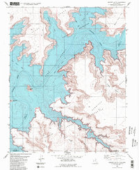
1985 Map of Gregory Butte
USGS Topo · Published 1985About this map
Lake Powell dominates this mid-1980s landscape, illustrating the flooded canyons following the completion of the Glen Canyon Dam. The map highlights the transition of the Colorado River into a massive reservoir, with the Normal Pool Elevation 3700 contour marking the new shoreline. Significant landforms like Gregory Butte and Gooseneck Point stand as high-elevation remnants above the water, while deep inlets such as Last Chance Bay and Friendship Cove snake into the surrounding Mesa terrain.
Find a feature on this map
24 named features on this map. Tap any name to fly to it.
Don’t see what you’re looking for? This feature index may not catch every label — zoom into the map to look around manually.
Map Details
Editions of this 1985 Gregory Butte Map
2 editions found
Other maps of this area

1886 · Escalante
USGS Topo · 1:250,000

1886 · Echo Cliffs
USGS Topo · 1:250,000

1891 · Echo Cliffs
USGS Topo · 1:250,000

1922 · Warm Creek
USGS Topo · 1:63,360

1953 · Cummings Mesa
USGS Topo · 1:62,500

1953 · Gunsight Butte
USGS Topo · 1:62,500

1954 · Leche-E Rock
USGS Topo · 1:62,500

1954 · Navajo Creek
USGS Topo · 1:62,500

1956 · Escalante
USGS Topo · 1:250,000

1956 · Marble Canyon
USGS Topo · 1:250,000