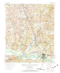
1954 Map of Grenada
USGS Topo · Published 1984About this map
The Yalobusha River and its newly formed reservoir dominate this mid-century landscape in north-central Mississippi. Following the Flood Control Act of 1954, the construction of the Grenada Dam significantly altered the terrain, creating Grenada Lake and impacting small riverside communities. The Illinois Central railroad serves as the primary industrial spine, connecting the major hub of Grenada with outlying points like Scobey and Tillatoba.
Find a feature on this map
84 named features on this map. Tap any name to fly to it.
Don’t see what you’re looking for? This feature index may not catch every label — zoom into the map to look around manually.
Map Details
Editions of this 1954 Grenada Map
2 editions found

Other maps of this area

1932 · Philipp
USGS Topo · 1:48,000

1935 · Crowder
USGS Topo · 1:62,500

1935 · Philipp
USGS Topo · 1:62,500

1936 · Greenwood
USGS Topo · 1:62,500

1939 · Crowder
USGS Topo · 1:62,500

1939 · Philipp
USGS Topo · 1:62,500

1940 · Greenwood
USGS Topo · 1:62,500

1948 · Helena
USGS Topo · 1:250,000

1950 · Helena
USGS Topo · 1:250,000

1953 · Greenwood
USGS Topo · 1:250,000