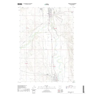
2017 Map of Greybull South
USGS Topo · Published 2017About this map
Bighorn River and Greybull River converge in this high-desert basin, defining the agricultural and transport corridors of Big Horn County. The towns of Greybull and Basin anchor the northern and southern reaches of the map, connected by a network of roads and irrigation infrastructure such as the Big Horn Canal and Shell Canal. This complex water system transformed the arid landscape into productive farmland, visible in the structured layouts of Basin Gardens Rd and Tin Can Aly. Genealogists will find significant local history in the cluster of burial sites, including the Donald J Ruhl Memorial Cem, Greybull Cem, and Hillside Cem to the north, and the Basin Pioneer Cem near the southern settlement. The topography is marked by distinctive erosion features like Schroll Draw and Frenchy Draw, illustrating the rugged drainage patterns that flank the river valleys.
Find a feature on this map
26 named features on this map. Tap any name to fly to it.
Don’t see what you’re looking for? This feature index may not catch every label — zoom into the map to look around manually.
Map Details
Editions of this 2017 Greybull South Map
This is the sole edition of this map. No revisions or reprints were ever made.
Other maps of this area

1898 · Bald Mountain
USGS Topo · 1:125,000

1901 · Bald Mountain
USGS Topo · 1:125,000

1955 · Cody
USGS Topo · 1:250,000

1955 · Sheridan
USGS Topo · 1:250,000

1958 · Cody
USGS Topo · 1:250,000

1958 · Sheridan
USGS Topo · 1:250,000

1960 · Manderson
USGS Topo · 1:24,000

1960 · Devils Kitchen
USGS Topo · 1:24,000

1960 · Wild Horse Flats
USGS Topo · 1:24,000

1962 · Sheridan
USGS Topo · 1:250,000