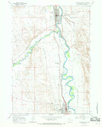
1966 Map of Greybull South
USGS Topo · Published 1969About this map
The Bighorn River meanders through this Wyoming valley, providing the lifeblood for the agricultural and municipal developments of the mid-1960s. The town of Greybull anchors the northern portion of the map, situated at the confluence where the Greybull River meets the larger Bighorn waterway. Further south, the town of Basin serves as a secondary hub, connected to its neighbor by the Chicago Burlington and Quincy railroad line that tracks the river's path.
Find a feature on this map
21 named features on this map. Tap any name to fly to it.
Don’t see what you’re looking for? This feature index may not catch every label — zoom into the map to look around manually.
Map Details
Editions of this 1966 Greybull South Map
2 editions found
Other maps of this area

1898 · Bald Mountain
USGS Topo · 1:125,000

1901 · Bald Mountain
USGS Topo · 1:125,000

1955 · Cody
USGS Topo · 1:250,000

1955 · Sheridan
USGS Topo · 1:250,000

1958 · Cody
USGS Topo · 1:250,000

1958 · Sheridan
USGS Topo · 1:250,000

1960 · Manderson
USGS Topo · 1:24,000

1960 · Devils Kitchen
USGS Topo · 1:24,000

1960 · Wild Horse Flats
USGS Topo · 1:24,000

1962 · Sheridan
USGS Topo · 1:250,000