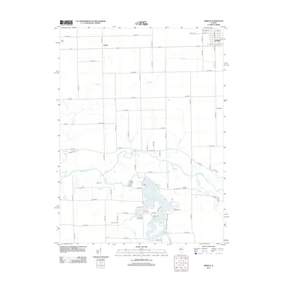
2012 Map of Gridley
USGS Topo · Published 2012About this map
The Mackinaw River winds across this Central Illinois landscape, anchoring a region defined by agricultural grid lines and the recreational developments around Lake Bloomington. Along the lake’s north-shore inlets, a cluster of group retreats including Camp Heffernan, Camp Peairs, and East Bay Camp suggests a transition from the intensive grain farming of the surrounding prairie to seasonal lakeside residency. In the upper right, the village of Gridley is mapped with street-level precision from Hillcrest St to 4th St, while the smaller settlement of Enright sits further west along the roadway. Genealogists will find several distinct burial sites across the township, such as the Messer Cem, Wilcox Coon Cem, and Hinthorn Cem, providing specific coordinates for tracing family roots. The map also captures the hydrological network of the Big Slough, Money Cr, and Wolf Cr as they feed into the larger river basin.
Find a feature on this map
73 named features on this map. Tap any name to fly to it.
Don’t see what you’re looking for? This feature index may not catch every label — zoom into the map to look around manually.
Map Details
Editions of this 2012 Gridley Map
This is the sole edition of this map. No revisions or reprints were ever made.
Other maps of this area

1926 · Normal
USGS Topo · 1:62,500

1927 · Danvers
USGS Topo · 1:62,500

1930 · Danvers
USGS Topo · 1:62,500

1930 · Normal
USGS Topo · 1:62,500

1955 · Minonk
USGS Topo · 1:62,500

1958 · Flanagan
USGS Topo · 1:62,500

1958 · Peoria
USGS Topo · 1:250,000

1961 · Peoria
USGS Topo · 1:250,000

1963 · Peoria
USGS Topo · 1:250,000
1970 · El Paso
USGS Topo · 1:24,000