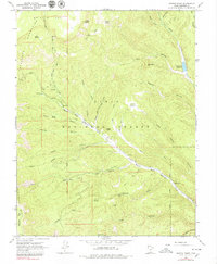
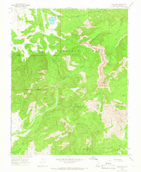
1964 Map of Griffin Point
USGS Topo · Published 1979About this map
Dixie National Forest covers the high-elevation terrain of the Escalante Mountains, where the landscape is defined by a network of steep canyons and isolated plateaus like Griffin Top. This mid-1960s survey illustrates a rugged backcountry environment where primary access relied on a pack trail or jeep trail rather than developed roads. The presence of the Corn Creek Mine and Cherry Creek Mine indicates historical extraction efforts tucked away in the deep drainages of Corn Creek and Cherry Creek. At the northeastern edge, the North Creek Reservoir sits at the confluence of North Fork Creek and its tributaries, serving as a critical water source for the arid region. The map also records early surveying landmarks, specifically the Salt Lake Meridian, which bisects the central peaks near Griffin Point.
Find a feature on this map
37 named features on this map. Tap any name to fly to it.
Don’t see what you’re looking for? This feature index may not catch every label — zoom into the map to look around manually.
Map Details
Editions of this 1964 Griffin Point Map
2 editions found
Other maps of this area

1886 · Escalante
USGS Topo · 1:250,000

1956 · Escalante
USGS Topo · 1:250,000

1960 · Escalante
USGS Topo · 1:250,000

1964 · Griffin Point
USGS Topo · 1:24,000

1964 · Barker Reservoir
USGS Topo · 1:24,000
1964 · Grass Lakes
USGS Topo · 1:24,000

1964 · Canaan Creek
USGS Topo · 1:24,000
1964 · Sweetwater Creek
USGS Topo · 1:24,000
1964 · Wide Hollow Reservoir
USGS Topo · 1:24,000
1964 · Pine Lake
USGS Topo · 1:24,000