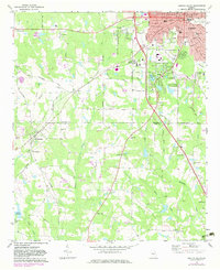
1971 Map of Griffin South
USGS Topo · Published 1983About this map
Griffin serves as the primary urban center on this 1970s-era map, with its detailed grid showing civic landmarks like the Courthouse, City Hall, and several educational institutions including Fourth Ward Sch and Third Ward Sch. The city's edge is defined by the Griffin-Spalding County Airport and the Municipal Park, while the surrounding Pike County and Spalding County countryside reveals a dense network of rural life. Numerous country churches such as Antioch Ch and Mt Gilead Ch are scattered across the landscape alongside the Southern rail line. The terrain is deeply grooved by waterways like Wasp Creek and Honey Bee Creek, which flow through a landscape marked by industrial activity at the Quarries and local family-named sites such as Lake Lewis. This survey captures the transition from a consolidated textile and rail hub into a modernizing regional landscape with expanded utility corridors like the Pipeline.
Find a feature on this map
46 named features on this map. Tap any name to fly to it.
Don’t see what you’re looking for? This feature index may not catch every label — zoom into the map to look around manually.
Map Details
Editions of this 1971 Griffin South Map
2 editions found
Other maps of this area

1951 · Barnesville
USGS Topo · 1:62,500

1953 · Atlanta
USGS Topo · 1:250,000

1957 · Atlanta
USGS Topo · 1:250,000

1958 · Atlanta
USGS Topo · 1:250,000

1964 · Luella
USGS Topo · 1:24,000

1965 · Griffin North
USGS Topo · 1:24,000

1965 · Brooks
USGS Topo · 1:24,000

1971 · Hollonville
USGS Topo · 1:24,000
1971 · Griffin South
USGS Topo · 1:24,000
1971 · Zebulon
USGS Topo · 1:24,000