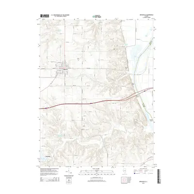
2015 Map of Griggsville
USGS Topo · Published 2015About this map
Griggsville stands as a central hub on the plateau overlooking the Illinois River valley, its grid of streets such as W Quincy St and E Liberty St reflecting a well-established settlement. To the east, the terrain breaks sharply into the bluffs of Church Hollow and Napoleon Hollow before meeting the river at Valley City. This transition from high farmland to river bottom is marked by several natural springs, including Anderson Spring and Winegar Spring, which have historically sustained the local ecology.
Find a feature on this map
61 named features on this map. Tap any name to fly to it.
Don’t see what you’re looking for? This feature index may not catch every label — zoom into the map to look around manually.
Map Details
Editions of this 2015 Griggsville Map
This is the sole edition of this map. No revisions or reprints were ever made.
Other maps of this area

1924 · Griggsville
USGS Topo · 1:62,500

1926 · Griggsville
USGS Topo · 1:62,500

1926 · Pittsfield
USGS Topo · 1:62,500

1926 · Mt Sterling
USGS Topo · 1:62,500

1928 · Meredosia
USGS Topo · 1:62,500

1929 · Mt Sterling
USGS Topo · 1:62,500

1931 · Meredosia
USGS Topo · 1:62,500

1948 · Quincy
USGS Topo · 1:250,000

1956 · Quincy
USGS Topo · 1:250,000
1975 · Meredosia SE
USGS Topo · 1:24,000