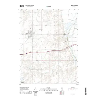
2021 Map of Griggsville
USGS Topo · Published 2021About this map
Griggsville and the surrounding Pike County countryside are defined by a network of drainage systems and ridge-top cemeteries. The eastern edge of the quadrangle is dominated by the Illinois River, which separates the county from the Scott County line and forms Big Blue Island. This riparian landscape is deeply incised by valleys like Napoleon Hollow, Church Hollow, and Hatch Hollow, providing a sharp contrast to the plateau where the municipal grid of Griggsville is established. Local family history and early settlement patterns are preserved through numerous rural burial grounds, including the Uriah Elledge Cem and Anderson Cem. To the south, the expansion of water resources is evident at Lake Pittsfield and the New Pittsfield Lake Number 2. Small-scale aviation and agricultural transport are represented by Curry Airport, tucked between the winding courses of Flint Cr and Blue Cr.
Find a feature on this map
61 named features on this map. Tap any name to fly to it.
Don’t see what you’re looking for? This feature index may not catch every label — zoom into the map to look around manually.
Map Details
Editions of this 2021 Griggsville Map
This is the sole edition of this map. No revisions or reprints were ever made.
Other maps of this area

1924 · Griggsville
USGS Topo · 1:62,500

1926 · Griggsville
USGS Topo · 1:62,500

1926 · Pittsfield
USGS Topo · 1:62,500

1926 · Mt Sterling
USGS Topo · 1:62,500

1928 · Meredosia
USGS Topo · 1:62,500

1929 · Mt Sterling
USGS Topo · 1:62,500

1931 · Meredosia
USGS Topo · 1:62,500

1948 · Quincy
USGS Topo · 1:250,000

1956 · Quincy
USGS Topo · 1:250,000
1975 · Meredosia SE
USGS Topo · 1:24,000