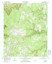
1954 Map of Grimsley
USGS Topo · Published 1979About this map
Grimsley and Banner Springs anchor this portion of the Cumberland Plateau in the 1950s, a landscape defined by deep-cut stream valleys and high wooded ridges. The Alvin C York Highway (Highway 127) serves as the primary north-south artery, connecting the community of Westmoreland to the Jamestown Municipal Airport. This area is characterized by a high density of family-named landmarks and rural institutions, including Tenchtown Ch and Tench Sch. The intricate drainage system of the Clear Fork and its various prongs—such as the North Prong Clear Fork and South Prong Clear Fork—creates a complex network of hollows that historically dictated settlement patterns. Small-scale industry is evidenced by scattered pits, while numerous burial grounds like Stephens Cem and Beaty Cem offer specific locations for genealogical research. Near the settlement of Allardt, the terrain drops toward Magendanz Falls, illustrating the transition from flat upland farms to the rugged gorge country typical of the Fentress and Morgan county line.
Find a feature on this map
52 named features on this map. Tap any name to fly to it.
Don’t see what you’re looking for? This feature index may not catch every label — zoom into the map to look around manually.
Map Details
Editions of this 1954 Grimsley Map
4 editions found

Other maps of this area

1895 · Wartburg
USGS Topo · 1:125,000

1896 · Wartburg
USGS Topo · 1:125,000

1897 · Standingstone
USGS Topo · 1:125,000

1898 · Standingstone
USGS Topo · 1:125,000

1935 · Clarkrange
USGS Topo · 1:24,000

1936 · Twin Bridges
USGS Topo · 1:24,000

1936 · Jones Knob
USGS Topo · 1:24,000

1943 · Twin Bridges
USGS Topo · 1:24,000
1945 · Twin Bridges
USGS Topo · 1:24,000

1946 · Clarkrange
USGS Topo · 1:24,000