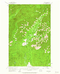
1955 Map of Grisdale
USGS Topo · Published 1963About this map
The industrial logging settlement of Grisdale serves as the central hub of this mid-century survey, situated within the dense timberlands of the Olympic National Forest. This era represents a period of intensive forest management and resource extraction, clearly evidenced by the winding path of the Schafer Logging Railroad which follows the Wynoochee River valley. The map documents a specialized landscape where remote outposts like the Satsop Guard Sta and high-altitude fire watch stations, including the Anderson Butte Lookout and Drake Lookout, provided critical oversight for the surrounding timber.
Find a feature on this map
63 named features on this map. Tap any name to fly to it.
Don’t see what you’re looking for? This feature index may not catch every label — zoom into the map to look around manually.
Map Details
Editions of this 1955 Grisdale Map
4 editions found

Other maps of this area

1921 · Quinault Lake
USGS Topo · 1:62,500

1921 · Satsop
USGS Topo · 1:62,500

1938 · Mt Constance
USGS Topo · 1:125,000

1941 · Mobray
USGS Topo · 1:62,500

1943 · Humptulips
USGS Topo · 1:62,500

1943 · Nahwatzel Lake
USGS Topo · 1:62,500

1943 · Mobray
USGS Topo · 1:62,500

1947 · Mt. Steel
USGS Topo · 1:62,500

1947 · Mt Christie
USGS Topo · 1:62,500

1950 · Mt Christie
USGS Topo · 1:62,500