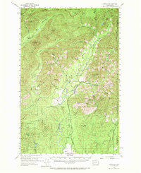
1955 Map of Grisdale
USGS Topo · Published 1970About this map
The timber settlement of Grisdale serves as the focal point of this mid-century survey, located where the Wynoochee River meets the expansive Weatherwax Basin. This era in the Olympic Peninsula's history is defined by the heavy logging infrastructure required to navigate the complex drainage systems of the Humptulips River, the Satsop River, and their numerous forks. Industrial activity is evidenced by the presence of the Schafer Railroad, which winds through the southeastern portion of the quadrangle, and a Landing Strip situated along the lower Wynoochee.
Find a feature on this map
64 named features on this map. Tap any name to fly to it.
Don’t see what you’re looking for? This feature index may not catch every label — zoom into the map to look around manually.
Map Details
Editions of this 1955 Grisdale Map
4 editions found

Other maps of this area

1921 · Quinault Lake
USGS Topo · 1:62,500

1921 · Satsop
USGS Topo · 1:62,500

1938 · Mt Constance
USGS Topo · 1:125,000

1941 · Mobray
USGS Topo · 1:62,500

1943 · Humptulips
USGS Topo · 1:62,500

1943 · Nahwatzel Lake
USGS Topo · 1:62,500

1943 · Mobray
USGS Topo · 1:62,500

1947 · Mt. Steel
USGS Topo · 1:62,500

1947 · Mt Christie
USGS Topo · 1:62,500

1950 · Mt Christie
USGS Topo · 1:62,500