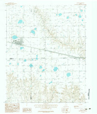
1983 Map of Groom
USGS Topo · Published 1984About this map
Groom serves as the central hub of this Texas Panhandle landscape, situated where the high plains begin to break into the drainage systems of the eastern Caprock. This 1983 provisional survey captures the town's layout during a period of infrastructure expansion, notably featuring a significant section of highway labeled Under Construction bypass south of the main town site. The physical geography is defined by the headwaters of Mc Clellan Creek and Sandy Creek, which carve distinct draws into the surrounding flatland. Across the prairie, smaller operations and landmarks like a remote Landing Strip and the settlement of Boydston to the east highlight the rural connectivity of the region. The map also meticulously delineates the meeting point of four counties—Carson, Gray, Armstrong, and Donley—providing a precise record of these shifting Indefinite Boundary lines during the early 1980s.
Find a feature on this map
11 named features on this map. Tap any name to fly to it.
Don’t see what you’re looking for? This feature index may not catch every label — zoom into the map to look around manually.
Map Details
Editions of this 1983 Groom Map
This is the sole edition of this map. No revisions or reprints were ever made.
Other maps of this area

1954 · Amarillo
USGS Topo · 1:250,000

1958 · Amarillo
USGS Topo · 1:250,000

1960 · Groom
USGS Topo · 1:62,500

1962 · Roach Ranch
USGS Topo · 1:24,000

1964 · Jericho
USGS Topo · 1:24,000

1966 · Grandview School
USGS Topo · 1:24,000

1966 · White Deer SW
USGS Topo · 1:24,000
1968 · Deep Lake
USGS Topo · 1:24,000
1983 · Shamrock
USGS Topo · 1:100,000
1983 · Ashtola
USGS Topo · 1:24,000