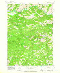
1964 Map of Grouse Butte
USGS Topo · Published 1966About this map
The South Fork Boise River carves through the northern reaches of the Sawtooth National Forest, providing a central corridor for recreation and early forest management in the mid-1960s. This survey records a landscape shaped by both natural drainage and human activity, characterized by numerous gulches like Virginia Gulch and Abbot Gulch that feed into the main river system. The presence of the Shake Creek Ranger Station and scattered sites such as Bird Creek Campground and Chaparral Campground indicate the area's importance as a managed wilderness and retreat. South of the river, the Soldier Mountains rise toward the prominent Grouse Butte. Local history and land use are evidenced by traces of the past such as Tailings near the river and the aptly named Schoolhouse Gulch, while a network of Pack Trails and Jeep Trails provides the primary means of navigating this high-altitude terrain.
Find a feature on this map
53 named features on this map. Tap any name to fly to it.
Don’t see what you’re looking for? This feature index may not catch every label — zoom into the map to look around manually.
Map Details
Editions of this 1964 Grouse Butte Map
2 editions found
Other maps of this area

1892 · Camas Prairie
USGS Topo · 1:125,000

1893 · Camas Prairie
USGS Topo · 1:125,000

1894 · Rocky Bar
USGS Topo · 1:125,000

1955 · Hailey
USGS Topo · 1:250,000

1959 · Hailey
USGS Topo · 1:250,000

1962 · Hailey
USGS Topo · 1:250,000

1963 · Deer Mountain
USGS Topo · 1:24,000
1963 · Sprout Mtn
USGS Topo · 1:24,000
1964 · Featherville
USGS Topo · 1:24,000

1964 · Ross Peak
USGS Topo · 1:24,000