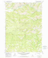
1964 Map of Grouse Butte
USGS Topo · Published 1987About this map
The South Fork Boise River cuts a deep corridor across the northern edge of this high-elevation landscape, where the Sawtooth Mountains and Soldier Mountains converge. This 1964 field-checked survey highlights a remote section of the Boise National Forest dedicated to mid-century forest management and recreation. The Shake Creek Ranger Station serves as the primary outpost for this rugged interior, situated near the confluence of several tributary drainages such as Regina Creek and Willow Creek.
Find a feature on this map
51 named features on this map. Tap any name to fly to it.
Don’t see what you’re looking for? This feature index may not catch every label — zoom into the map to look around manually.
Map Details
Editions of this 1964 Grouse Butte Map
2 editions found
Other maps of this area

1892 · Camas Prairie
USGS Topo · 1:125,000

1893 · Camas Prairie
USGS Topo · 1:125,000

1894 · Rocky Bar
USGS Topo · 1:125,000

1955 · Hailey
USGS Topo · 1:250,000

1959 · Hailey
USGS Topo · 1:250,000

1962 · Hailey
USGS Topo · 1:250,000

1963 · Deer Mountain
USGS Topo · 1:24,000
1963 · Sprout Mtn
USGS Topo · 1:24,000
1964 · Featherville
USGS Topo · 1:24,000

1964 · Ross Peak
USGS Topo · 1:24,000