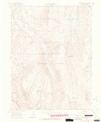
1962 Map of Grouse Mountain
USGS Topo · Published 1964About this map
Baryeta Cabins sit tucked in the high timber of the White River National Forest, reflecting the era of remote mountain habitations before the expansion of modern resorts. This mid-century landscape is defined by its industrial and agricultural water systems, from the subterranean works of the Discovery Tunnel and Ohio Tunnel to the gravity-fed Fleck Ditch and Howard Ditch. The network of high-altitude water bodies, including the Upper Turquoise Lake and Lower Turquoise Lake, highlights the importance of mountain runoff to the region. To the north, the terrain transitions through open areas like McCoy Park and Snowslide Park, while drainage systems like Bachelor Gulch and Creamery Gulch descend toward the valleys. The presence of an unnamed Mine and various ditch systems like the Bragg No 1 Ditch point to the dual reliance on mineral extraction and water rights in this part of Eagle County.
Find a feature on this map
45 named features on this map. Tap any name to fly to it.
Don’t see what you’re looking for? This feature index may not catch every label — zoom into the map to look around manually.
Map Details
Editions of this 1962 Grouse Mountain Map
5 editions found

Other maps of this area

1889 · Leadville
USGS Topo · 1:125,000

1891 · Leadville
USGS Topo · 1:125,000

1909 · Mount Jackson
USGS Topo · 1:125,000

1911 · Mount Jackson
USGS Topo · 1:125,000

1934 · Minturn
USGS Topo · 1:62,500

1942 · Leadville
USGS Topo · 1:125,000

1949 · Holy Cross
USGS Topo · 1:62,500

1950 · Minturn
USGS Topo · 1:62,500

1951 · Holy Cross
USGS Topo · 1:62,500

1957 · Leadville
USGS Topo · 1:250,000