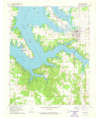
1971 Map of Grove
USGS Topo · Published 1973About this map
Lake O' the Cherokees dominates this 1971 study, showing the intricately fingered shoreline of the Neosho River valley after its transformation into a major reservoir. The town of Grove is the primary hub, showing early 1970s infrastructure including a Pumping Sta, Hosp, and an Old RR Grade that hints at the area's former transit routes. The map records several aviation landmarks along the water, from the Seaplane Base to the Shangri-La Airport and Monkey Island Airport, reflecting the region's mid-century growth as a recreation and travel destination.
Find a feature on this map
49 named features on this map. Tap any name to fly to it.
Don’t see what you’re looking for? This feature index may not catch every label — zoom into the map to look around manually.
Map Details
Editions of this 1971 Grove Map
2 editions found
Other maps of this area

1899 · Siloam Springs
USGS Topo · 1:125,000

1903 · Siloam Springs
USGS Topo · 1:125,000

1904 · Siloam Springs
USGS Topo · 1:125,000

1907 · Wyandotte
USGS Topo · 1:125,000

1909 · Wyandotte
USGS Topo · 1:125,000

1954 · Tulsa
USGS Topo · 1:250,000

1958 · Tulsa
USGS Topo · 1:250,000

1963 · Tulsa
USGS Topo · 1:250,000
1964 · Cayuga
USGS Topo · 1:24,000

1964 · Dodge
USGS Topo · 1:24,000