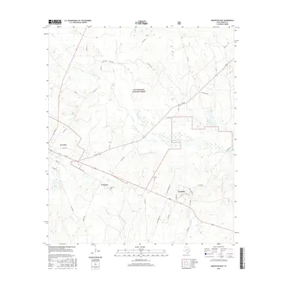
2016 Map of Groveton East
USGS Topo · Published 2016About this map
Groveton anchors this East Texas landscape, where the town's industrial roots are still visible along Sawmill Rd and near the rail-oriented settlement of Josserand. The terrain is defined by a dense network of tributaries including Upper Kickapoo Cr, Piney Cr, and Kemper Cr, which carve through the woodlands of the Davy Crockett National Forest. Local history and genealogy researchers will find several well-documented burial sites such as Lacy Cem, Josserand Cem, and Sumpter Cem, providing vital clues to the early families of Trinity County. The presence of Woodlake and various water bodies like Pine Lake and Ritter Lake illustrate the area's timber and recreational legacy. Roads like Kickapoo Rd and Josserand Rd follow long-established paths through the piney woods, connecting the central township to the surrounding forest interior.
Find a feature on this map
51 named features on this map. Tap any name to fly to it.
Don’t see what you’re looking for? This feature index may not catch every label — zoom into the map to look around manually.
Map Details
Editions of this 2016 Groveton East Map
This is the sole edition of this map. No revisions or reprints were ever made.
Other maps of this area

1953 · Palestine
USGS Topo · 1:250,000

1954 · Beaumont
USGS Topo · 1:250,000

1955 · New Willard
USGS Topo · 1:62,500

1957 · Beaumont
USGS Topo · 1:250,000

1957 · Palestine
USGS Topo · 1:250,000

1960 · Colita
USGS Topo · 1:24,000

1963 · Crecy
USGS Topo · 1:24,000

1963 · Groveton West
USGS Topo · 1:24,000
1963 · Pennington
USGS Topo · 1:24,000

1963 · Groveton East
USGS Topo · 1:24,000